
Understand the geography, strategic significance, security challenges, and policy responses related to the Chicken’s Neck Corridor—India’s critical link connecting the Northeast with the mainland. Very Important Topic for APSC CCE and UPSC CSE, both Prelims and Mains Examinations.
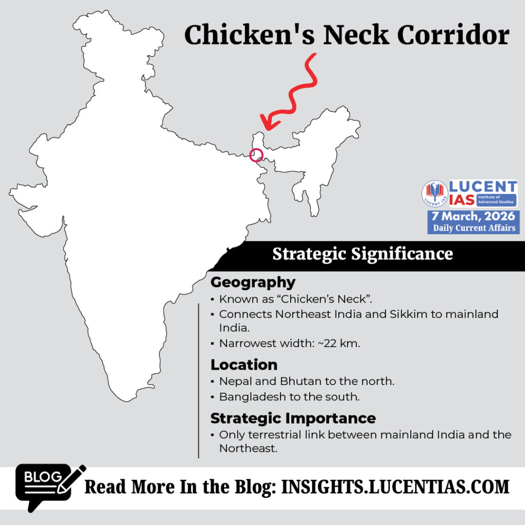
The Siliguri Corridor, popularly known as the “Chicken’s Neck”, is one of the most strategically sensitive geographic regions in India. This narrow strip of land connects mainland India with the North eastern states and Sikkim, making it a crucial lifeline for national integration, economic connectivity, and defence logistics.
Due to its narrow width and complex geopolitical environment, the corridor has long been considered a strategic bottleneck for India’s security planners.
Geographic Significance
The Siliguri Corridor is located in northern West Bengal and serves as the only land link between mainland India and the eight Northeastern states.
Key geographical features include:
- Known as “Chicken’s Neck” because of its narrow shape.
- Narrowest width: Approximately 22 km.
- Northern boundaries: Nepal and Bhutan.
- Southern boundary: Bangladesh.
- Acts as a gateway connecting the Northeast and Sikkim with the rest of India.
Because of this unique geography, any disruption in the corridor could significantly affect transport, communication, and supply chains to the Northeast.
Strategic Importance
The corridor holds immense strategic importance for India for several reasons:
1. Territorial Connectivity
- It is the only terrestrial link between mainland India and the Northeastern region.
- Essential for civilian movement, trade, and defence logistics.
2. Military Significance
- Provides the primary route for deployment and supply of armed forces to the Northeast.
- Critical during border tensions with neighbouring countries.
3. Economic Link
- Facilitates movement of goods, essential supplies, and trade to and from the North eastern states.
- Supports integration of the region with national markets and infrastructure networks.
Strategic Vulnerabilities
Despite its importance, the Siliguri Corridor faces several vulnerabilities.
1. Geographic Bottleneck
- Its extremely narrow width makes it a potential choke point.
- Any disruption—military or natural—could isolate the entire Northeast from mainland India.
2. External Security Concerns
- China’s infrastructure development in the Chumbi Valley, located near the India–Bhutan–China tri-junction, increases strategic pressure on the corridor.
- The Doklam standoff (2017) highlighted how developments in this region could directly affect India’s security interests.
3. Internal Security Challenges
The corridor is also vulnerable to various internal threats, such as:
- Illegal migration and infiltration
- Drug trafficking
- Human trafficking
- Use of routes for insurgent supply chains
These transnational crimes exploit the porous borders and complex terrain of the region.
Development and Diplomatic Initiatives
To reduce dependence on the Siliguri Corridor and enhance connectivity, India has adopted several infrastructure and diplomatic initiatives.
1. Connectivity through Bangladesh
India has expanded transport and trade routes through Bangladesh, including:
- Access to Bangladesh ports
- Railway connectivity
- Road transit agreements
These initiatives provide alternative connectivity routes to the Northeast.
2. Kaladan Multi-Modal Transit Transport Project
The Kaladan project through Myanmar connects:
- Kolkata port
- Sittwe port in Myanmar
- Inland waterways and roads to Mizoram
This creates another route to the Northeast that bypasses the corridor.
3. Infrastructure Development
India has also strengthened infrastructure in the Northeast, including:
- Bogibeel Bridge across the Brahmaputra
- Bhupen Hazarika Bridge (Dhola–Sadiya Bridge)
- Expansion of national highways and strategic roads
These projects improve mobility, logistics, and defence preparedness.
Key Policy Recommendations
Given its strategic sensitivity, several policy measures are necessary to strengthen the corridor.
1. Integrated Security Management
- Establish an integrated security command involving the Army, BSF, and State Police.
- Improve coordination for border management and intelligence sharing.
2. Technology-Driven Surveillance
- Deploy AI-enabled monitoring systems.
- Use drones and smart surveillance technologies for real-time monitoring.
3. Socio-Economic Development
- Improve infrastructure, employment opportunities, and social services in local communities.
- Local development helps reduce illegal activities and insurgency support networks.
4. Disaster-Resilient Infrastructure
- Build redundant and climate-resilient transport networks.
- Ensure connectivity even during floods or natural disasters.
5. Regional Diplomacy
- Strengthen cooperation with neighbouring countries, especially Bangladesh.
- Promote regional connectivity frameworks to diversify access routes to the Northeast.
The Siliguri Corridor remains one of the most strategically critical geographic spaces in India. Its narrow geography makes it both a vital lifeline and a potential vulnerability. Strengthening infrastructure, enhancing security mechanisms, leveraging technology, and deepening regional cooperation are essential to ensure that this corridor continues to support India’s national security, regional connectivity, and economic integration.
Practice Questions for Civil Services Examination
UPSC CSE / APSC CCE Mains Questions
1. The Siliguri Corridor is often described as India’s strategic “bottleneck.” Examine its geopolitical significance and the challenges it poses to India’s national security.
2. Discuss the role of regional connectivity initiatives such as the Kaladan Multi-Modal Transit Transport Project and India–Bangladesh transport links in reducing India’s dependence on the Siliguri Corridor.
UPSC CSE / APSC CCE Prelims MCQ (Statement-Based)
Consider the following statements regarding the Siliguri Corridor:
- The Siliguri Corridor connects mainland India with the Northeastern states and Sikkim.
- It lies between Nepal and Bhutan in the north and Bangladesh in the south.
- The narrowest width of the corridor is about 100 km.
Which of the statements given above is/are correct?
A. 1 and 2 only
B. 2 and 3 only
C. 1 and 3 only
D. 1, 2 and 3
Correct Answer: A
Explanation:
Statements 1 and 2 are correct. The Siliguri Corridor connects the Northeast with mainland India and lies between Nepal and Bhutan to the north and Bangladesh to the south. Statement 3 is incorrect because the corridor’s narrowest width is about 22 km, not 100 km.
About Lucent IAS
Lucent IAS is a premier coaching institute in Guwahati, dedicated to empowering APSC aspirants with a result-oriented approach. Recognized as a top destination for APSC Coaching, we offer comprehensive guidance ranging from Foundation Courses and Advanced Mains preparation to our signature Assam-Centric study modules. With expert faculty, small batch sizes for personalized mentoring, and the acclaimed Saadhana Test Series, Lucent IAS is committed to helping you crack the Civil Services Examination.
Publications From LUCENT IAS
- “The Assam Odyssey: The Complete Assam Centric Resource useful for APSC CCE and various other Departmental Examinations. Read More
- InExam PYQ Explained.Read More
- Mains Tattva: The Craft of Answer Writing (GS Paper PYQs). Read More
- Maanchitra – An Illustrative Colour-Coded Informative Map of Assam. Read More
- প্ৰাৰম্ভ (Prarambha). Read More
- অসম ওডিচী – The Assam Odyssey (Assamese Edition). Read More
Start your journey to success today. Visit us at lucentias.com or call +91-6913007777 for more details.